
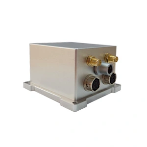
Low-cost MEMS Integrated Navigation System
Introduction
ER-GNSS/MINS-05 is a low-cost integrated navigation system that significantly reduces hardware costs. Through technology and system optimization, it accurately balances and compensates key indicators such as accuracy, reliability, and stability under cost constraints, providing a truly low-cost navigation solution for automation, unmanned systems, precision agriculture and other fields.
It deeply integrates inertial and satellite data, outputs full-parameter navigation information including position, speed, attitude, and heading, and achieves centimeter-level positioning accuracy and 0.03m/s speed measurement accuracy, 0.1° real-time heading accuracy (0.05° after post-processing), and 0.1° attitude accuracy (0.03° after post-processing). When the GNSS signal is lost or interfered, the IMU maintains navigation output through short-term calculation to avoid positioning interruption.
Reduce the cost of expensive inertial devices, use highly reliable and low-cost MEMS gyroscopes and accelerometers, and perform temperature compensation for gyroscopes and accelerometers within the operating temperature range of -40℃~+80℃, which is different from the high cost of traditional high-end devices, while reducing hardware costs and ensuring core performance.
Built-in full-band full-system dual-antenna GNSS module, a single machine can simultaneously achieve three functions: positioning, speed measurement, and orientation. Single-antenna positioning and speed measurement meet the needs of mainstream scenarios such as unmanned systems and agricultural plant protection drones; dual-antenna rapid orientation provides a reliable benchmark for autonomous vehicle steering decisions and aircraft formation coordination.
Equipped with a variety of communication interfaces and providing standardized user communication protocols, with the core advantages of "balanced performance, controllable costs, and full parameter information", it can meet a variety of applications such as aviation and land.
Feature
1.The system can provide accurate integratednavigation information, with attitude up to 0.1°, post-processing 0.03°, heading 0.1°, post-processing 0.05°.
2.Maintain high-precision navigation for a short time in an environment where the satellite signal is lost.
3.High reliability and low cost MEMS gyroscope (bias instability <2°/h) and MEMS accelerometer (bias instability <25ug).
4.The working temperature is -40℃~+80℃, and the temperature compensation of the gyroscope and accelerometer is carried out in the working temperature range, which has better zero bias performance.
5.Built-in full-band full-system dual-antenna positioning and orientation GNSS module, supporting single-antenna high-precision positioning and velocity measurement, supporting dual-antenna fast orientation function.
6.Supports RTK and can adaptively identify RTCM.
7.Variety of data interface, more easy to install and use, support RS422/RS232 and CAN.
8.Precision aluminum alloy shell, high reliability, can be widely used in land, navigation
Application areas
UAV, flight recorders, intelligent unmanned vehicles,
roadbed positioning and orientation, waterway detection, precision agriculture, ROV navigation
Specifications
1. System parameter
| ER-GNSS/MINS-05 | ||
| Roll & Pitch Accuracy | 0.1° | |
| 0.03°(Post Processing) | ||
| Heading | 0.1°Dual Antenna GNSS(baseline 1m) | |
| 0.05°(Post Processing) | ||
| Speed accuracy | 0.03m/s | |
| RTK 30 sec outage | Roll&Pitch | Heading |
| 0.03° | 0.06° | |
| Position(X/Y) | Altitude(Z) | |
| 1.0m | 0.5m | |
| RTK 60 sec outage | Roll&Pitch | Heading |
| 0.1° | 0.2° | |
| Position(X/Y) | Altitude(Z) | |
| 15m | 3m | |
| Alignment Time | 3min (Dual Antenna GNSS) | |
2. Sensor parameter
| Gyro Performance | ||
| Item | Parameter | Unit |
| Range | ±500 | deg/s |
| Angle random walk | ≤0.15 | °/ √h |
| Bias instability | ≤2 | °/h |
| Bias stability (1σ) | ≤8 | °/h |
| Bias repeatability (1σ) | ≤8 | °/h |
| Accelerometer Performance | ||
| Item | Parameter | Unit |
| Range | ±16 | g |
| Bias stability (1σ) | ≤0.2 | mg |
| Bias repeatability (1σ) | ≤0.2 | mg |
| Barometer | ||
| Parameter | value | Unit |
| Pressure range | 10~1200 | mbar |
| Accuracy 25℃,750mbar | ±1.5 | mbar |
| Error band,-20℃~+85℃,450~1100mabr | ±2.5 | mbar |
| Temperature | -40℃~+85℃ | \ |
| Long-term stability | ±1 | mbar/year |
| Magnetometer | ||
| Sensor Filed Range | ±2 | gauss |
| Sensitivity | 11000 | LSB/G |
| Temperature Sensor
Sensitivity |
14 | LSB/℃ |
| Field Resolution | 1.2 | mgauss |
| X-Y-Z Orthogonality | 90±1 | Degree |
| GNSS | ||||
| Supported Navigation System | BDS/GPS/GLONASS/Galileo/QZSS | |||
| Main ANT Frequency | BDS:B1L, B2L, B3L
GPS:L1C/A, L2P(Y)/L2C, L5 GLONASS:G1,G2 Galileo: E1, E5a, E5b QZSS: L1, L2, L5 |
|||
| Slave ANT Frequency | BDS:B1L, B2L, B3L
GPS:L1C/A, L2C GLONASS: G1,G2 Galileo: E1, E5b QZSS: L1, L2 |
|||
| Position Accuracy (RMS) | Single point positioning | Horizontal | 1.5m | |
| Altitude | 2.5m | |||
| DGPS | Horizontal | 0.4m+1ppm | ||
| Altitude | 0.8m+1ppm | |||
| RTK | Horizontal | 0.8cm+1ppm | ||
| Altitude | 1.5cm+1ppm | |||
| Accuracy of observation (RMS) | ||||
| BDS | GPS | GLONASS | Galileo | |
| B1I/L1 C/A/G1/E1 pseudo-range | 10cm | 10cm | 10cm | 10cm |
| B1I/L1 C/A/G1/E1 Carrier Phase | 1mm | 1mm | 1mm | 1mm |
| B3I/L2P(Y)/L2C/G2 pseudo-range | 10cm | 10cm | 10cm | 10cm |
| B3I/L2P(Y)/L2C/G2 Carrier Phase | 1mm | 1mm | 1mm | 1mm |
| B2I/L5/E5a/E5b pseudo-range | 10cm | 10cm | 10cm | 10cm |
| B2I/L5/E5a/E5b Carrier Phase | 1mm | 1mm | 1mm | 1mm |
| Time accuracy (RMS) | 20ns | |||
| Speed accuracy (RMS) | 0.03m/s | |||
| First positioning time | <30s | |||
| Initialization time | <5s | |||
| Data update rate | <20Hz | |||
| Power & Interface | |
| Supply Voltage | 5~12V |
| Supply Consumption | 4W |
| Interface | 1Way-RS422 or 1Way-RS232 and 1Way-CAN and 2Way-TTL(NMEA out and RTCM in) |
| Environment | |
| Operate Temp | -40℃~+80℃ |
| Storage Temp | -55℃~+95℃ |
| Dimension & Weight | |
| Weight | <200g |
| Size | 65mm*70mm*45.5mm |
More Technical Questions
1. What Is GNSS-aided MEMS INS and How Does It Work?
2. How to Improve the Performance of MEMS Inertial Navigation Systems?
3. Full-temperature Performance Optimization Method For MEMS accelerometer
4. Classification And Performance Improvement Of MEMS Gyroscope
5. MEMS Accelerometer Packaging Technology
6. Performance Analysis of GNSS RTK Timing
More Products