
Introduction
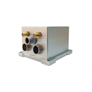
ER-GNSS/MINS-03 is a cost-effective MEMS integrated navigation system that deeply integrates GNSS and IMU. With high performance and high cost-effectiveness as the core design concept, it adopts tactical-grade MEMS inertial devices to obtain high-precision integrated navigation information while keeping the cost under control.
Equipped with integrated navigation fusion algorithm, it can provide continuous, accurate and reliable positioning, attitude and speed information under complex GNSS conditions. The heading accuracy can reach 0.05° (post-processing accuracy 0.01°), and the output attitude accuracy is 0.02° (post-processing 0.01°).
When the GNSS signal is lost or interfered with (entering a tunnel, urban canyon, or being interfered with by electromagnetic interference), the IMU can maintain high-precision position, attitude (accuracy 0.01°), and heading (accuracy 0.02°) outputs for a short period of time until the GNSS signal is restored.
Equipped with tactical-grade high-precision and high-reliability MEMS gyroscopes (bias instability <0.3°/h) and high-precision MEMS accelerometers (bias instability <10ug), it can maintain excellent sensor performance while reducing costs.
It integrates a dual-antenna full-system full-frequency positioning and directional satellite module to perform RTK positioning and dual-antenna directional solution, single-antenna positioning and speed measurement, and dual-antenna rapid orientation. The satellite receiver has built-in anti-interference, and can still provide accurate and reliable satellite positioning in complex electromagnetic environments.
It has a variety of communication interfaces and provides standardized user communication protocols to meet aviation, land and other applications.
Feature
1.The system can provide accurate integrated navigation information, with attitude up to 0.02°, post-processing 0.01°, heading 0.05°, and post-processing 0.01°.
2.In the environment where the satellite signal is lost, maintain 30s of high-precision navigation, attitude (accuracy 0.01°), heading (accuracy 0.02°).
3.High reliability and high precision MEMS gyroscope (bias instability <0.3°/h) and high precision MEMS accelerometer (bias instability <10ug).
4.The working temperature is -40℃~+80℃, and the temperature compensation of the gyroscope and accelerometer is carried out in the working temperature range, which has better bias performance.
5.Built-in full-band full-system dual-antenna positioning and orientation GNSS module, supporting single-antenna high-precision positioning and velocity measurement, supporting dual-antenna fast orientation function.
6.The satellite receiver has built-in anti-interference and can provide accurate and reliable satellite positioning even in complex electromagnetic environments.
7.Variety of data interface, more easy to install and use, support RS422/RS232 and CAN
8.Precision aluminum alloy shell, high reliability, can be widely used in land, aviation.
Application areas
UAV, flight recorders, intelligent unmanned vehicles
roadbed positioning and orientation
Specifications
1.System parameter
| ER-GNSS/MINS-03 | ||
| Roll & Pitch Accuracy | 0.02° | |
| 0.01°(Post Processing) | ||
| Heading | 0.05° Dual Antenna GNSS (baseline 2m) | |
| 0.01° (Post Processing) | ||
| Speed accuracy | 0.03m/s | |
| RTK 30 sec outage | Roll&Pitch | Heading |
| 0.01° | 0.02° | |
| Position(X/Y) | Altitude(Z) | |
| 0.5m | 0.25m | |
| RTK 60 sec outage | Roll&Pitch | Heading |
| 0.02° | 0.03° | |
| Position(X/Y) | Altitude(Z) | |
| 1.5m | 1.0m | |
| Alignment Time | 3min (Dual Antenna GNSS) | |
2.Sensor parameter
| Gyro Performance | ||
| Item | Parameter | Unit |
| Range | ±400 | deg/s |
| Bandwidth (-3dB) | 250 | Hz |
| Scale Factor at 25℃ | 16000 | LSB/deg/s |
| Scale Factor Repeatability (1σ) | <50 | ppm |
| Scale Factor VS Temperature (1σ) | ±300 | ppm |
| Scale Factor Non-Linearity (1σ) | <300 | ppm |
| Bias Instability | <0.3 | deg/hr |
| Bias stability (1σ 10s) | <3 | deg/hr |
| Bias repeatability (1σ) | <3 | deg/hr |
| Angular Random Walk | <0.125 | °/ √h |
| Noise Peak to Peak | ±0.2 | deg/s |
| Accelerometer Performance | ||
| Item | Parameter | Unit |
| Range | ±10 | g |
| Bandwidth | 100 | Hz |
| Bias stability (1σ 10s) | <150 | ug |
| Bias stability (Allen) | <100 | ug |
| Bias Month repeatability | 200 | mg |
| Factor Scale non-linearity | <500 | ppm |
| Factor Scale Temp Coefficient | 120 | ppm/℃ |
| Class II Non-linearity Coefficient | <100 | ug/g2 |
| Scale Factor | 800000 | LSB/g |
| GNSS | ||||
| Supported Navigation System | BDS/GPS/GLONASS/Galileo/QZSS | |||
| Main ANT Frequency | BDS:B1L, B2L, B3L
GPS:L1C/A, L2P(Y)/L2C, L5 GLONASS:G1,G2 Galileo: E1, E5a, E5b QZSS: L1, L2, L5 |
|||
| Slave ANT Frequency | BDS:B1L, B2L, B3L
GPS:L1C/A, L2C GLONASS: G1,G2 Galileo: E1, E5b QZSS: L1, L2 |
|||
| Position Accuracy (RMS) | Single point positioning | Horizontal | 1.5m | |
| Altitude | 2.5m | |||
| DGPS | Horizontal | 0.4m+1ppm | ||
| Altitude | 0.8m+1ppm | |||
| RTK | Horizontal | 0.8cm+1ppm | ||
| Altitude | 1.5cm+1ppm | |||
Accuracy of observation (RMS) |
||||
| BDS | GPS | GLONASS | Galileo | |
| B1I/L1 C/A/G1/E1 pseudo-range | 10cm | 10cm | 10cm | 10cm |
| B1I/L1 C/A/G1/E1 Carrier Phase | 1mm | 1mm | 1mm | 1mm |
| B3I/L2P(Y)/L2C/G2 pseudo-range | 10cm | 10cm | 10cm | 10cm |
| B3I/L2P(Y)/L2C/G2 Carrier Phase | 1mm | 1mm | 1mm | 1mm |
| B2I/L5/E5a/E5b pseudo-range | 10cm | 10cm | 10cm | 10cm |
| B2I/L5/E5a/E5b Carrier Phase | 1mm | 1mm | 1mm | 1mm |
| Time accuracy (RMS) | 20ns | |||
| Speed accuracy (RMS) | 0.03m/s | |||
| First positioning time | <30s | |||
| Initialization time | <5s | |||
| Data update rate | <20Hz | |||
| Power & Interface | |
| Supply Voltage | 6~12V |
| Supply Consumption | 5W |
| Interface | 1Way-RS422 or 1Way-RS232 and 1Way-CAN and 2Way-TTL(NMEA out and RTCM in) |
| Environment | |
| Operate Temp | -40℃~+80℃ |
| Storage Temp | -55℃~+95℃ |
| Dimension & Weight | |
| Weight | <300g |
| Size | 65mm*70mm*45.5mm |
More Technical Questions
1. What Is GNSS-aided MEMS INS and How Does It Work?
2. How to Improve the Performance of MEMS Inertial Navigation Systems?
3. Full-temperature Performance Optimization Method For MEMS accelerometer
4. Classification And Performance Improvement Of MEMS Gyroscope
5. MEMS Accelerometer Packaging Technology
6. Performance Analysis of GNSS RTK Timing
More Products