
ER-GNSS/MINS-07 Low Cost Single Antenna MEMS Integrated Navigation System
Introduction
ER-GNSS/MINS-07 is equipped with a highly reliable MEMS IMU and integrates a single-antenna full-system multi-frequency positioning satellite module. It is a low-cost single-antenna integrated navigation system.
Equipped with a integrated navigation fusion algorithm, it can provide continuous, accurate and reliable positioning, attitude, and speed information, with attitude up to 0.1° and heading 0.1°.
It uses a low-cost MEMS inertial measurement unit (IMU), internally integrated with a three-axis MEMS gyroscope and accelerometer, and a -40℃~+80℃ full-temperature range temperature compensation algorithm, which greatly reduces costs while ensuring core performance.
Different from the complex structure and cost of traditional dual-antenna solutions, ER-GNSS/MINS-07 adopts a single-antenna full-system dual-frequency design to achieve high-precision positioning and speed measurement.
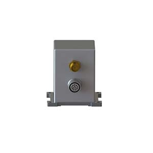
The precision aluminum alloy shell has high reliability and adapts to harsh environments. It has a variety of communication interfaces and provides standardized user communication protocols to meet aviation, land and other applications.
Feature
The system can provide accurate combined navigation information, with attitude up to 0.1° and heading 0.1°.
High reliability and low-cost MEMS IMU. Operating temperature -40℃~+80℃.
Built-in single-antenna full-system multi-frequency GNSS module, supporting single-antenna high-precision positioning and speed measurement.
Multiple data interfaces, easier to install and use, supporting RS422/RS232 and CAN.
Precision aluminum alloy housing, high reliability, can be widely used in land and aviation.
Application areas
UAV, flight recorder, ADS
Specification
1.System parameter
| ER-GNSS/MINS-07 | ||
| Roll & Pitch | 0.1° | |
| Heading(dynamic) | 0.2° | |
| Heading(magnetic compass) | 0.8° | |
| Speed accuracy | 0.02 m/s | |
| RTK 30 sec outage | Roll & Pitch | Heading |
| 0.05° | 0.1° | |
| Position (X/Y) | Altitude (Z) | |
| 1.0 m | 0.5 m | |
| RTK 60 sec outage | Roll & Pitch | Heading |
| 0.1° | 0.2° | |
| Position (X/Y) | Altitude (Z) | |
| 15 m | 3 m | |
| Alignment Time | 3 min | |
2.Sensor parameter
| IMU Performance | ||
| Item | Value | Unit |
| Gyro range | ±125、500、1000、2000 | deg/s |
| Gyro ARW | 0.21 | °/ √h |
| Gyro sensitivity | 4.37 @FS=±125
17.5@FS=±500 35.0@FS=±1000 70.0@FS=±2000 |
mdps/LSB |
| Gyro Bias instability | 3 | °/h |
| Acc Range | ±2、4、8、16 | g |
| Acc sensitivity | 0.061@FS=±2
0.122@FS=±4 0.244@FS=±8 0.488@FS=±16 |
mg/LSB |
| Acc Bias stability | 0.1 | mg |
| Barometer | ||
| Parameter | value | Unit |
| Range | 10~1200 | mbar |
| Accuracy 25℃, 750mbar | ±1.5 | mbar |
| Error band, -20℃~+85℃, 450~1100mabr | ±2.5 | mbar |
| Temperature | -40℃~+85℃ | \ |
| Long-term stability | ±1 | mbar/year |
| Magnetometer | ||
| Range | ±2 | gauss |
| Sensitivity | 11000 | LSB/G |
| Temperature Sensor
Sensitivity |
14 | LSB/℃ |
| Field Resolution | 1.2 | mgauss |
| X-Y-Z Orthogonality | 90±1 | Degree |
| Satellite Receiver | |||
| Supported Navigation System | GPS/BDS-2/BDS-3/GLONASS/Galileo/QZSS/SBAS/IRNSS | ||
| ANT Frequency | GPS: L1C/A,L2P, L2C, L5
BDS-2: B11, B21, B31 BDS-3: B11, B3l, B2a GLONASS: G1,G2 Galileo: El,E5b, E5a QZSS*: L1C/A, L2C, L5 SBAS*: L1C/A, L5 IRNSS*: L5 |
||
| Position Accuracy (RMS) | Single point positioning | Horizontal | 1.5m |
| Altitude | 3m | ||
| RTK
|
Horizontal | ±(8+10-6×D)mm
D represents the baseline length(mm) |
|
| Altitude | ±(15+10-6×D)mm
D represents the baseline length(mm) |
||
| Time accuracy (RMS) | 20ns | ||
| Speed accuracy (RMS) | 0.02m/s | ||
| First positioning time | 24s | ||
| Power & Interface | |
| Supply Voltage | 5~12V |
| Supply Consumption | 3W |
| Interface | 1-Way RS422 or 1-Way RS232 and 1-Way CAN and 1-Way TTL (NMEA output and RTCM input) |
| Environment | |
| Operate Temp | -40℃~+80℃ |
| Storage Temp | -55℃~+95℃ |
| Dimension | |
| Dimension | 40mm*40mm*45mm |
More Technical Questions
1. What Is GNSS-aided MEMS INS and How Does It Work?
2. How to Improve the Performance of MEMS Inertial Navigation Systems?
3. Full-temperature Performance Optimization Method For MEMS accelerometer
4. Classification And Performance Improvement Of MEMS Gyroscope
5. MEMS Accelerometer Packaging Technology
6. Performance Analysis of GNSS RTK Timing
More Products