

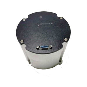
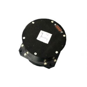
Ultra-Small Fiber Optic Integrated Navigation System
Product introduction
The ER-FINS-50 is a high-performance, ultra-compact GNSS +fiber-optic gyroscope integrated navigation system. The ER-FINS-50 integrated navigation system has a built-in high-performance GNSS board with Feiner latitude and longitude, supports BDS, GPS, GLONASS three-system RTK high-precision positioning, adopts independent intellectual property rights of fast carrier phase ambiguity solution technology and multipath suppression algorithm, can quickly and accurately solve centimeter-level position information, can receive RTCM data from multiple ground reference stations at the same time, and supports short, medium and long baseline RTK solution.
The ER-FINS-50 integrated navigation system adopts the smallest optical fiber IMU device in China, which can adapt to a variety of use environments; The use of high-reliability closed-loop fiber optic gyroscopes and accelerometers can ensure the measurement accuracy through a number of compensation techniques.
The integrated navigation system has a built-in multi-language Web GUI, which can realize hands-on configuration, graphical data display and remote upgrade;The integrated navigation system also features convenient and easy-to-use web configuration interface, which greatly reduces the threshold of use, and has a rich interface to adapt to various application scenarios.
It can be widely used in high-precision surveying and mapping, mechanical control, displacement and deformation monitoring, precision agriculture, exploration, transportation, etc.
Product Features
Support BDS/GPS/GLONASS/QZSS
Centimeter-level high-precision RTK positioning, support integrated navigation
Built-in high-performance fiber optic IMU, which can adapt to a variety of usage environments
Supports multiple differential data formats: RTCM2.x/3.x CMR CMR+
High level of protection and security level IP67
Flexible and abundant external interfaces, support serial port, Ethernet, CAN, USB 2.0 OTG, support TF card storage
Integrated DTU supports 4G transmission (can support global full Netcom)
Support NTP, FTP file download, FTP push, email abnormal alarm
Support Feiner custom ASCII and Binary format output, BINEX standard data format
Built-in web interface for board upgrades, configurations, controls, and status queries
Specification
| Performance specifications | ||||
|
Receive satellite signals |
GPS L1/L2 | |||
| BDS B1/B2 | ||||
| GLONASS L1/L2 | ||||
| QZSS L1/L2 | ||||
| Single Frequency Positioning (RMS)
|
Plane | 1.5m | ||
| Elevation | 3.0m | |||
| Dual Frequency Positioning (RMS)
|
Plane | 1.2m | ||
| Elevation | 2.5m | |||
| DGNSS(RMS) | Plane | 0.4m | ||
| Elevation | 0.8m | |||
| RTK (RMS)
|
Plane | 10mm +1ppm | ||
| Elevation | 15mm +1ppm | |||
| Orientation Accuracy (RMS) | 0.2° / 1m baseline | |||
| Velocity Accuracy (RMS) | 0.03m/s | |||
| Time Accuracy (RMS) | 20ns | |||
| Measurement accuracy | BDS | GPS | GLONASS | QZSS |
| B1/L1 C/A | 10cm | 10cm | 10cm | 10cm |
| B1/L1 carrier phase | 1mm | 1mm | 1mm | 1mm |
| B2/L2P(Y) code | 10cm | 10cm | 10cm | 10cm |
| B2/L2 carrier phase | 1mm | 1mm | 1mm | 1mm |
| Initialization time | <10 seconds (typical value) | |||
| Time to first fix (TTFF) | Cold start: 40s (typical) | |||
| Warm Start: 30s (typical) | ||||
| Hot Start: 5s (typical) | ||||
| Differential data | RTCM2.x/3.x CMR CMR+ | |||
| Data format | NMEA-0183, BINEX | |||
| Femtomes ASCII and Binary formats | ||||
| GNSS data updates | 1Hz/5Hz/10Hz/20Hz | |||
| Integrated Navigation/IMU Raw Data Update | Supports up to 200Hz | |||
| Inertial navigation accuracy | <0.1% x distance traveled (within 30s without GNSS signal) | |||
| IMU Indicators | |
| Fiber optic gyroscope | |
| Measuring range (º/sec) | 500 |
| Bias stability (º/hr) | 0.5 |
| Bias repeatability (º/hr) | 0.5 |
| Angle Random Walk (º/ √ hr) | 0.5 |
| Bandwidth (Hz) | 200 |
| Scale Factor Non-linearity (ppm) | 100 |
| Accelerometer | |
| Measuring range (g) | 25 |
| Bias Stability (㎍) | 20 |
| Biased Repeatability (㎍) | 200 |
| Scale Factor Nonlinearity (ppm) | 300 |
| GNSS performance after lockout | ||||||||
| Interruption time | Positioning mode | Position accuracy (m) RMS | Velocity accuracy (m/s) RMS | Attitude accuracy (°)RMS | ||||
| Horizontal accuracy | Vertical accuracy | Horizontal accuracy | Vertical accuracy | Roll | Pitch | Heading | ||
| 0s | RTK | 0.020 | 0.030 | 0.015 | 0.010 | 0.020 | 0.020 | 0.060 |
| Single point | 1.000 | 0.600 | 0.020 | 0.010 | 0.020 | 0.020 | 0.060 | |
| Post-processing | 0.010 | 0.020 | 0.020 | 0.010 | 0.015 | 0.015 | 0.030 | |
| 10s | RTK | 0.260 | 0.160 | 0.045 | 0.024 | 0.030 | 0.030 | 0.080 |
| Single point | 1.210 | 0.730 | 0.050 | 0.024 | 0.030 | 0.030 | 0.080 | |
| Post-processing | 0.020 | 0.020 | 0.020 | 0.020 | 0.015 | 0.015 | 0.030 | |
| Physical property | |
| Dimension | Φ89mm*108.5mm |
| Weight | <700g |
| Antenna Interface | SMA-F |
| 4G Antenna Interface | SMA-F |
| Protection Rating | IP67 |
| Operating Temperature | -40℃~60℃ |
| Storage Temperature | -55℃~70℃ |
| Humidity | 95% No condensation |
| Impact | 80g/3ms |
| Vibration | 6.06g (rms) |
| Electrical characteristics | |
| Input voltage | 9-36VDC( typical value 12VDC) |
| power consumption | <10W |
| Antenna matching impedance | 50Ω |
| Functional Interfaces | |
| Serial Port | 2x UART/RS232( optional ) |
| UART 3.3V LV-TTL | |
| Maximum 460800bps | |
| USB | 1x USB 2.0 OTG |
| Storage | TF card 32G |
| Communication Interface | CAN |
| Communication mode | Ethernet 4G |
| 1pps output | 1x LV-TTL 3.3V or 5V |
| Event Input | 1x LV-TTL 3.3V or 5V |
Application Techniques
1.Inertial Navigation System (INS)
2.What is Inertial Navigation System?
3.MEMS and FOG: How Should you Choose Inertial Navigation System?
4.In Autonomous Flight: How Inertial Navigation Systems Work
5.Development and Application of Inertial Navigation System
6.Introduction to Inertial Navigation Systems
More Products