


ER-MNS-06AD Low Cost MEMS North Seeker for Heading Machine
Introduction
ER-MNS-06AD is an ultra-low-cost MEMS north seeker mainly used for tunnel boring machines. It adopts the latest MEMS gyro technology and is a precision measurement and orientation device that breaks through the traditional volume advantage. It has the characteristics of small size, light weight, and low power consumption.
The compact size and lightweight structure greatly reduce the requirements for installation space and can be seamlessly embedded in narrow space scenes. It is mainly used in mining engineering, underground tunneling, construction and other fields. It can be integrated in engineering machinery such as tunnel boring machines and mining equipment, as well as various fields that require orientation.
Different from traditional magnetic compasses, the north finder is completely unaffected by the geomagnetic field. It adopts three-axis MEMS gyroscope and three-axis MEMS accelerometer strapdown inertial measurement technology. It does not require external reference signals to solve the carrier attitude and north azimuth. It can still maintain stable output in strong magnetic environments, high-latitude geomagnetic anomaly areas or electromagnetic pulse environments.
Technical Features
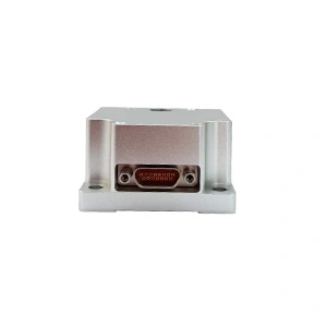
- Adopt the latest MEMS gyro technology, the volume is extremely reduced, the size is only 38.6×44.8×25.5mm, easy to integrate;
- Adopt the latest three-axis MEMS gyro, three-axis MEMS accelerometer strapdown inertial measurement technology;
- With self-seeking function;
- Not affected by magnetic field;
- Light weight, low power consumption;
- 5°C to 55°C temperature compensation;
Applications
Direction of advanced mining/drilling equipment
Excavation operations in underground tunnels of coal mines, metal mines, etc., suitable for large equipment such as cantilever tunneling machines and continuous coal miners
Orientation and attitude measurement of transportation equipment such as mining AGV in underground tunnels
Precision platform attitude measurement and control
Bridge, high-rise building, high tower, dam monitoring
Specifications
| Model No. | ER-MNS-06AD |
| Azimuth accuracy (1σ,°secψ) | 1 |
| Attitude accuracy(1σ,°) | ≤0.3 |
| Azimuth accuracy retaining accuracy | 20min |
| Attitude accuracy retaining accuracy | 20min |
| Azimuth measurement range(°) | 0~360 |
| Inclination angle measurement range(°) | -85~85 |
| North seeking time | 180s |
| North seeking method | stationary |
| Update Rate (Hz) | 100 |
| Power and environment | |
| Operating temperature (℃) | 5~+55 |
| Storage temperature (℃) | 0~+65 |
| Power supply (V) | 6~12V |
| Power (W) | 2 |
| Communication interface | RS-422 |
| Physical characteristics | |
| Size (mm×mm×mm) | 38.6×44.8×25.5 |
| Weight (g) | ≤70g |
Wiring Definition
| Connect Type | Pin | Definition |
| J30J-15ZKP | 1 | 6~12V |
| 3 | GND | |
| 6 | Tx+ | |
| 7 | Tx- | |
| 8 | Rx+ | |
| 9 | Rx- |
Dimension

Data protocols
Upper computer receiving protocol
The data update rate is 100Hz, the baud rate is 230400bps, and each frame contains 61 bytes of data, each byte contains 1 start bit (0), 8 data bits, 1 stop bit (1), and no parity. The specific data format is shown in the table below:
Table 1 Receive data frame format
| Bytes (60 bytes total) | Data content | supplementary note |
| 1~4 | header | EB8055AA |
| 5~8 | X Gyro Data | Low then high, dimensionless digital FLOAT |
| 9~12 | Y gyro data | Low then high, dimensionless digital FLOAT |
| 13~16 | Z Gyro Data | Low then high, dimensionless digital FLOAT |
| 17~20 | X ACCL data | Low then high, dimensionless digital FLOAT |
| 21~24 | Y ACCL data | Low then high, dimensionless digital FLOAT |
| 25~28 | Z ACCL data | Low then high, dimensionless digital FLOAT |
| 29~32 | Lon | Low then high, 0.000001°. |
| 33~36 | Lat | Low then high, 0.000001°. |
| 37~40 | Alt | First low, then high, 0.000001m |
| 41~44 | register | Low then high, 10ms |
| 45~46 | PIT | Low then high, 0.01° |
| 47~48 | ROL | Low then high, 0.01° |
| 49~50 | YAW | Low then high, 0.01° |
| 51~52 | V_n | First low then high, 0.01m/s |
| 53~54 | V_u | First low then high, 0.01m/s |
| 55~56 | V_e | First low then high, 0.01m/s |
| 57 | state of affairs | 0xA1 alignment, 0xB1 hold |
| 58 | end of frame | 0x00 |
| 59 | end of frame | 0xFF |
| 60 | end of frame | 0x34 |
| 61 | matching test | EB 80 and the sum of all bytes other than itself |
Host computer sending protocol
Total number of bytes sent down in a single transmission: 21 bytes, baud rate 230400bps, no parity, each byte includes: start bit (0), data bit (8 bits), stop bit (1).
- priming
| byte symbol | define | note |
| 1 | 0xEB | |
| 2 | 0x80 | |
| 3 | 0x00 | |
| 4 | 0xCC | |
| 5-8 | 0x00 | |
| 9-12 | 0x00 | |
| 13-16 | 0x00 | |
| 17-21 | 0x00 |
- Send warp and woof height
| byte symbol | define | note |
| 1 | 0xEB | |
| 2 | 0x80 | |
| 3 | 0x00 | |
| 4 | 0xAA | |
| 5-8 | Latitude | |
| 9-12 | longitudes | |
| 13-16 | Altitude | |
| 17 | 0xAA | |
| 18 | 0xBB | |
| 19 | 0xCC | |
| 20 | 0xDD | |
| 21 | 5~20 heterodyne calibration |
Determine the definition of the data sent based on byte 4:
- if control_flag==0xCC: restart work
- if control_flag==0xAA: send latitude/longitude altitude
Send order: 5-8 bytes: latitude (*1e6 in °)
9-12 bytes: longitude (*1e6 in °)
13-16 bytes: altitude (*1 in m)
For example, the C code that sends the latitude/longitude instruction (the rest of the bytes are configured arbitrarily), Latitude is "latitude * 1e6", longitude is similar, and altitude scale is 1.
bytSend[0] = 0xeb;
bytSend[1] = 0x80;
bytSend[2] = 0x00;
bytSend[3] = 0xaa;
bytSend[4] = (Latitude>>24) & 0xff;
bytSend[5] = (Latitude>>16) & 0xff;
bytSend[6] = (Latitude>>8) & 0xff;
bytSend[7] = (Latitude) & 0xff.
bytSend[8] = (Longitude>>24) & 0xff;
bytSend[9] = (Longitude>>16) & 0xff;
bytSend[10] = (Longitude>>8) & 0xff;
bytSend[11] = (Longitude) & 0xff.
bytSend[12] = (altitude>>24) & 0xff;
bytSend[13] = (altitude>>16) & 0xff;
bytSend[14] = (altitude>>8) & 0xff;
bytSend[15] = (altitude) & 0xff;
bytSend[16] = 0xaa;
bytSend[17] = 0xbb;
bytSend[18] = 0xcc;
bytSend[19] = 0xdd;
bytSend[20] = b[4]^b[5]^... .b[19];
Introduction to the software
Click the COMCFG button to set the serial port, baud rate and frequency. The baud rate is 230400 and the frequency CAL is 100HZ.
Click Open to start the test.
Double click Initial Align to start the north search, the search time is 300s.The result is displayed at PIT;YAW;ROL.
If you want to change the latitude and longitude, please change them at Lon0 and Lat0, then click Load, and then click Initial Align to re-navigate.

Application Techniques
1.Applicable to coal mines, tunnels, and exploration! North seeker's strength revealed
2.How important is the North Seeker in the field of oil、mining and drilling?
4.Efficient mining, north seeker assists mining drilling operations
5.Accurate orientation, easy to deal with! North seeker helps work more efficiently
More Products
 Ultra-small Size OEM MEMS North Seeker
 Smallest Volume MEMS North Seeker
 High Performance North Seeking MEMS Gyroscope
 High Accuracy MEMS Accelerometer
 Low Cost 3 Axis FOG North Seeker