

Introduction
As industries increasingly rely on autonomous navigation, motion control, and real-time positioning, obtaining accurate attitude information has become essential. Whether in UAV flight control, marine navigation, robotics, autonomous vehicles, or surveying equipment, knowing a platform's orientation directly impacts performance and safety.
This is where an Attitude and Heading Reference System (AHRS) becomes critical.
An AHRS continuously calculates and outputs roll, pitch, and heading angles by combining data from gyroscopes, accelerometers, and magnetometers. Compared with traditional mechanical gyroscopes, modern MEMS-based AHRS solutions provide higher reliability, lower power consumption, and easier integration.
In this guide, we explain how AHRS works, compare AHRS with IMU and INS systems, and examine real-world industrial AHRS specifications using ERICCO ER-AHRS-5 and ER-AHRS-7 as examples.
What Is an AHRS?
An AHRS (Attitude and Heading Reference System) is an electronic navigation device that determines and reports the orientation of a vehicle or platform relative to the Earth.
A modern AHRS typically provides:
- Roll Angle
- Pitch Angle
- Heading (Yaw)
- Angular Velocity
- Linear Acceleration
- Magnetic Field Information
These outputs are essential for navigation, stabilization, and control systems.
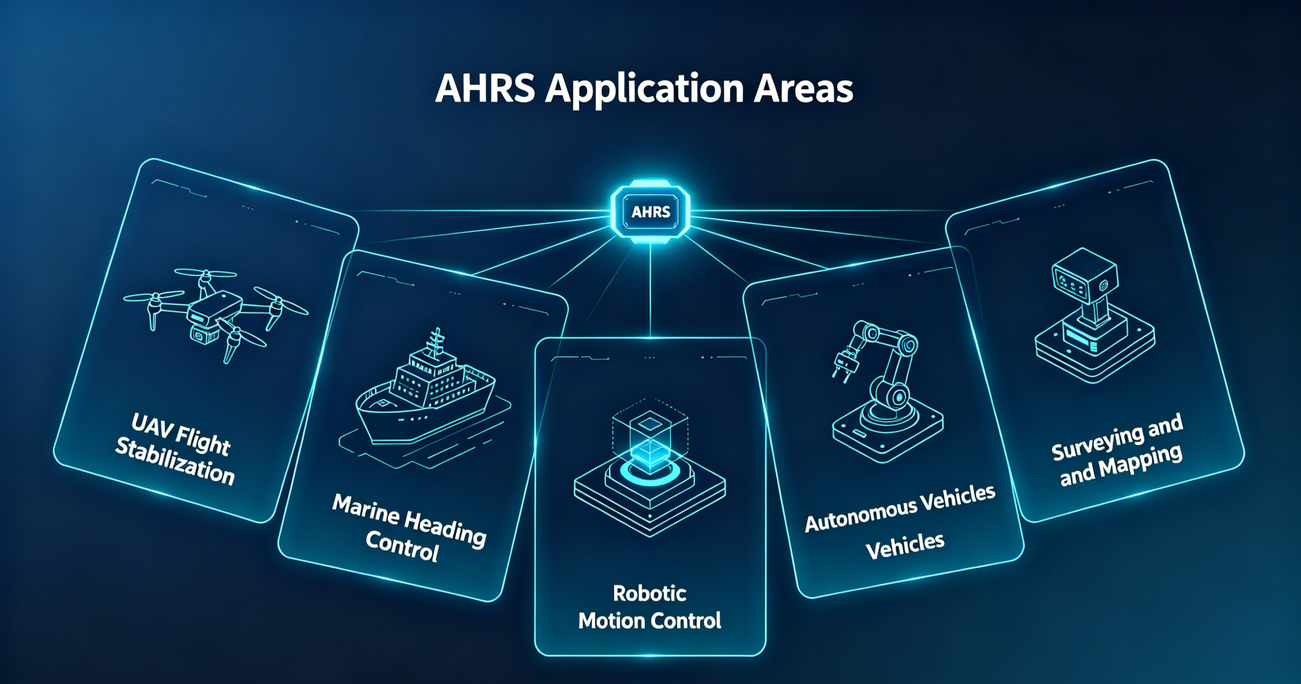
AHRS systems are widely used in:
- UAVs and drones
- Marine vessels
- Autonomous vehicles
- Mobile mapping systems
- Industrial robots
- Surveying instruments
- Antenna stabilization platforms
Why Is AHRS Important in Navigation Systems?
Many people assume GPS alone is sufficient for navigation.
In reality, GPS only provides position information.
It cannot accurately determine:
- Vehicle attitude
- Platform orientation
- Instant angular movement
For example, a drone may know its location from GPS, but without AHRS data it cannot determine:
- Whether it is rolling left or right
- Whether it is pitching upward
- Which direction it is facing
This is why AHRS has become a core component of modern navigation systems.
How Does an AHRS Work?
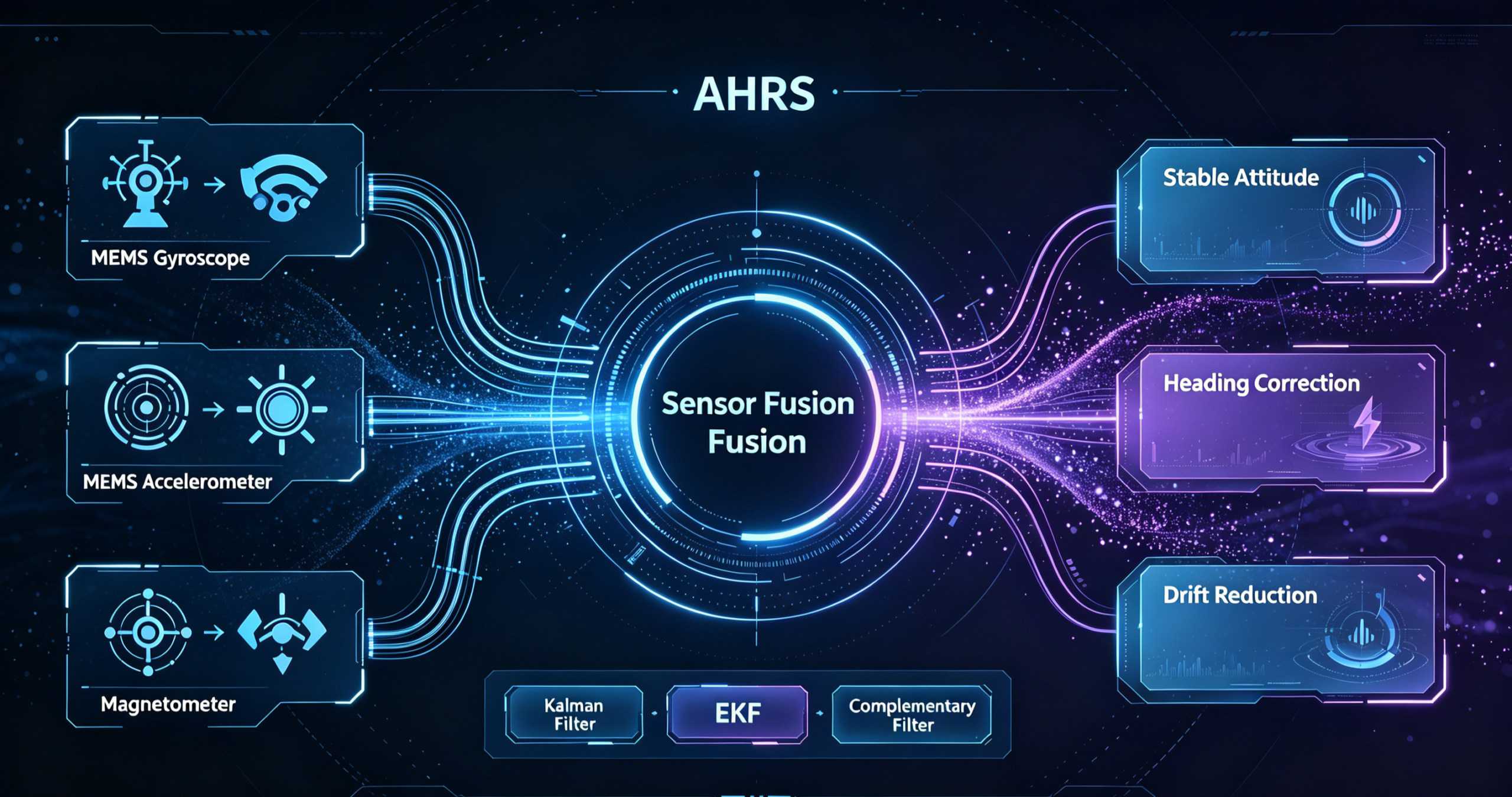
An AHRS combines data from multiple sensors using sensor fusion algorithms.
MEMS Gyroscopes
Gyroscopes measure angular velocity around three axes.
They provide:
- Fast response
- High update rates
- Short-term attitude tracking
However, gyroscopes accumulate drift over time.
MEMS Accelerometers
Accelerometers measure gravitational acceleration.
They help determine:
- Roll angle
- Pitch angle
Accelerometers provide long-term stability and correct gyroscope drift.
Magnetometers
Magnetometers measure the Earth's magnetic field.
Their primary function is:
- Heading determination
- Yaw correction
Sensor Fusion Algorithms
Modern AHRS systems combine all sensor measurements through algorithms such as:
- Kalman Filter
- Extended Kalman Filter (EKF)
- Complementary Filter
The result is a highly stable attitude solution even under vibration and dynamic motion conditions.
Technical Specifications of a Modern Industrial AHRS
Understanding AHRS performance requires more than knowing its working principle.
Engineers typically evaluate:
- Heading accuracy
- Gyroscope stability
- Update rate
- Environmental adaptability
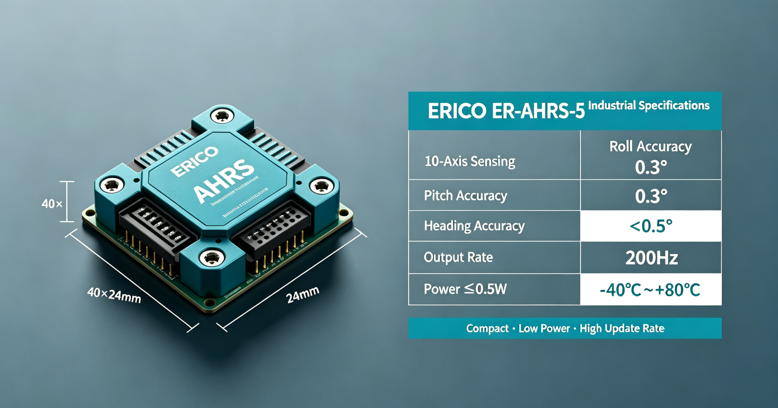
Taking ERICCO ER-AHRS-5 as an example, the system integrates:
- 3-axis MEMS gyroscope
- 3-axis MEMS accelerometer
- 3-axis magnetometer
- High-resolution barometer
forming a complete 10-axis inertial sensing architecture.
ER-AHRS-5 Key Specifications
| Specification | ER-AHRS-5 |
|---|---|
| Sensor Configuration | 10-Axis |
| Roll Accuracy | 0.3° |
| Pitch Accuracy | 0.3° |
| Heading Accuracy | <0.5° |
| Gyroscope Bias Instability | ≤3°/h |
| Angle Random Walk | ≤0.21°/√h |
| Output Rate | 200Hz |
| Static Drift | 0.5° / 10min |
| Power Consumption | ≤0.5W |
| Input Voltage | 5V–12V |
| Operating Temperature | -40°C~+80°C |
| Dimensions | 40×40×24mm |
These specifications demonstrate why industrial AHRS systems are widely adopted in UAV navigation, robotic control, and marine guidance applications.
How Accurate Is an AHRS?
Accuracy is one of the most important factors when selecting an AHRS.
The following parameters determine overall performance:
| Parameter | Typical Industrial Value |
|---|---|
| Roll Accuracy | 0.3° |
| Pitch Accuracy | 0.3° |
| Heading Accuracy | <0.5° |
| Bias Instability | ≤3°/h |
| Random Walk | ≤0.21°/√h |
| Output Frequency | 200Hz |
A high-performance AHRS should maintain attitude accuracy even during:
- Vibration
- Shock
- Temperature fluctuations
- Dynamic acceleration
For applications such as UAV flight stabilization and autonomous navigation, heading accuracy below 1° is often required.
AHRS vs IMU: What Is the Difference?
Many users confuse AHRS and IMU systems.
Although the hardware is similar, the outputs are very different.
| Feature | AHRS | IMU |
|---|---|---|
| Gyroscope | ✓ | ✓ |
| Accelerometer | ✓ | ✓ |
| Magnetometer | ✓ | Optional |
| Sensor Fusion | ✓ | ✗ |
| Roll/Pitch Output | ✓ | ✗ |
| Heading Output | ✓ | ✗ |
| Orientation Solution | ✓ | ✗ |
IMU
Provides raw sensor data.
AHRS
Provides processed attitude and heading information.
For most UAV, robotics, and marine projects, AHRS significantly reduces software development complexity.
AHRS vs INS: What Is the Difference?
Another common question is whether AHRS can replace an INS.
The answer is no.
| Feature | AHRS | INS |
|---|---|---|
| Roll/Pitch | ✓ | ✓ |
| Heading | ✓ | ✓ |
| Velocity | ✗ | ✓ |
| Position | ✗ | ✓ |
| Navigation Solution | Partial | Complete |
| Cost | Lower | Higher |
AHRS provides orientation.
INS provides:
- Orientation
- Velocity
- Position
Therefore, AHRS is often integrated as a subsystem within an INS.
ER-AHRS-5 vs ER-AHRS-7
To help engineers select the appropriate solution, let's compare two industrial AHRS products from ERICCO.
| Specification | ER-AHRS-5 | ER-AHRS-7 |
|---|---|---|
| Roll Accuracy | 0.3° | 0.3° |
| Pitch Accuracy | 0.3° | 0.3° |
| Heading Accuracy | <0.5° | <1° |
| Gyroscope Bias Instability | ≤3°/h | ≤3°/h |
| Output Rate | 200Hz | 200Hz |
| Communication | RS232/RS422/CAN | RS232/RS422/CAN |
| Power Consumption | ≤0.5W | ≤0.5W |
| Operating Temperature | -40°C~+80°C | -40°C~+80°C |
ER-AHRS-5
Best suited for:
- Precision UAVs
- Marine navigation
- Mobile mapping
- Autonomous navigation
ER-AHRS-7
Best suited for:
- Industrial robots
- UAV stabilization
- AGV systems
- Cost-sensitive projects
Common Applications of AHRS
UAV Flight Control
AHRS provides real-time attitude information for:
- Flight stabilization
- Autopilot systems
- Payload control
A heading accuracy of <0.5° allows more stable navigation during autonomous missions.
Marine Navigation
AHRS supports:
- Vessel heading control
- Dynamic positioning
- Unmanned surface vessels
The wide operating temperature range of -40°C to +80°C makes industrial AHRS systems suitable for harsh marine environments.
Robotics
Industrial robots use AHRS data for:
- Motion tracking
- Balance control
- Autonomous navigation
Compact dimensions such as 40×40×24 mm enable easy integration into robotic systems.
Autonomous Vehicles
Self-driving platforms require precise attitude information for:
- Path planning
- Dead reckoning
- Vehicle stabilization
AHRS often works alongside GNSS and INS systems to improve reliability.
Surveying and Mapping
AHRS plays a critical role in:
- Mobile mapping systems
- LiDAR scanning
- Hydrographic surveying
Accurate attitude data directly affects mapping precision.
How to Choose the Right AHRS
When selecting an AHRS, engineers should consider:
1. Attitude Accuracy
Typical requirements:
- General robotics: <1°
- UAV navigation: <0.5°
- Mapping systems: <0.3°
2. Gyroscope Stability
Bias instability determines long-term performance.
Industrial-grade systems generally require: ≤3°/h or better.
3. Output Frequency
Fast-moving platforms often require:
- 100Hz
- 200Hz
- 500Hz
The ER-AHRS series supports 200Hz output, suitable for most industrial applications.
4. Environmental Conditions
Evaluate:
- Temperature range
- Shock resistance
- Vibration tolerance
Industrial applications often require operation from -40°C to +80°C.
5. Communication Interfaces
Common interfaces include:
- RS232
- RS422
- CAN Bus
Selecting compatible interfaces simplifies system integration.
FAQ
Q: Can AHRS work without GPS?
A: Yes. AHRS uses inertial sensors and magnetometers and does not require GPS for attitude estimation.
Q: Is AHRS more accurate than an IMU?
A: AHRS is not necessarily more accurate, but it provides processed attitude information directly, making it easier to deploy.
Q: Can AHRS replace INS?
A: No. INS provides position and velocity, while AHRS only provides orientation information.
Q: What industries use AHRS?
A: Common industries include:
- UAVs
- Marine navigation
- Robotics
- Autonomous vehicles
- Surveying and mapping
- Defense systems
Conclusion
An Attitude and Heading Reference System (AHRS) is one of the most important components in modern navigation and motion-control systems. By combining MEMS gyroscopes, accelerometers, magnetometers, and advanced sensor fusion algorithms, AHRS delivers reliable real-time orientation data for UAVs, marine vessels, robots, autonomous vehicles, and surveying equipment.
Industrial-grade products such as ERICCO's ER-AHRS-5 and ER-AHRS-7 demonstrate how modern AHRS technology can achieve roll and pitch accuracy of 0.3°, heading accuracy better than 0.5°, 200Hz output rates, and stable operation from -40°C to +80°C.
For engineers seeking a balance between performance, reliability, and integration simplicity, AHRS remains one of the most cost-effective attitude sensing solutions available today.