

Quick Answer
GNSS gives you position, but it cannot give you accurate attitude, it drops out under trees and between buildings, and it updates too slowly for fast-moving sensors. A GNSS-aided inertial system (GNSS/INS) fuses satellite position with an inertial measurement unit: the INS tracks position, velocity, and roll, pitch, and heading at a high rate, and GNSS continuously corrects the drift. For mobile mapping, UAV LiDAR, handheld, and marine survey work, the fusion is what makes the collected data georeferenced accurately. Pick the system by attitude accuracy, heading especially, by how long it holds accuracy without GNSS, and by whether the job needs RTK or PPK-level position.
Ten years ago, the standard answer in surveying was "just use GPS." Nobody says that anymore. Crews who tried it found the signal dying under trees, between buildings, and at tunnel entrances. They found they could get position but not attitude, so a laser scanner or camera pointed the wrong way. They found the heading jumping every time the vehicle bounced.
None of that was equipment failure. It was the boundary of GPS as a technology. Satellite navigation tells you where the receiver is. It does not tell you which way the sensor on top of the vehicle is pointing, and it stops working where the sky is blocked.
GNSS-aided inertial navigation exists to cover that gap. This article explains what the fusion actually does, why survey work specifically needs it, and which specifications to compare when you are choosing a GNSS/INS system.
Why GNSS Alone Is Not Enough for Surveying
It helps to be precise about what GNSS cannot do, because most survey problems trace back to one of these four limits.
GNSS has no attitude. A GNSS receiver computes position and velocity. It does not measure roll, pitch, or heading. But a mobile mapping system does not need just "where the vehicle is." It needs to know the orientation of every LiDAR line and every camera frame. Without attitude, the point cloud and imagery cannot be georeferenced. A GNSS receiver alone cannot produce a usable survey product.
GNSS drops out in real working environments. Tree canopy, urban canyons, bridge underpasses, tunnels, and rail cuts all block or degrade satellite signals. In exactly the places surveyors spend their time, GNSS goes intermittent. When the signal returns, it can take time to reacquire, and multipath reflections from buildings corrupt the fix.
GNSS updates too slowly for moving sensors. Consumer-grade receivers update at 10 to 20 Hz, and even survey-grade receivers update far below the rate of a fast-moving scanner or a maneuvering UAV. Between updates, the sensor is flying blind. At survey speeds, that gap translates directly into motion blur and distorted geometry in the collected data.
Raw GNSS accuracy is not survey grade. A standard single-frequency fix is accurate to meters. Survey work needs centimeters to decimeters, which is why RTK and PPK processing exist. RTK needs a live correction link, which fails exactly where the signal is weak.
None of these are new problems. They are why the industry moved from GPS receivers to integrated GNSS/INS systems.
What an INS Adds
An inertial navigation system (INS) is built around an inertial measurement unit (IMU), which contains gyroscopes and accelerometers. It measures how the platform is rotating and accelerating, hundreds of times per second, and integrates those measurements into position, velocity, and full attitude: roll, pitch, and heading.
The INS is self-contained. It does not need satellites, radio links, or any external signal, so it keeps working under trees, in tunnels, and between buildings. It measures attitude continuously, which is exactly what georeferencing needs. And it updates at a rate high enough to keep up with any scanner or camera.
The INS has one weakness: drift. Integration accumulates small sensor errors over time, so an INS running alone slowly wanders. A good IMU drifts less than a poor one, but all of them drift eventually. That single weakness is why an INS is not used alone in surveying, and it is also why the fusion with GNSS is so natural.
How GNSS-Aided Fusion Works
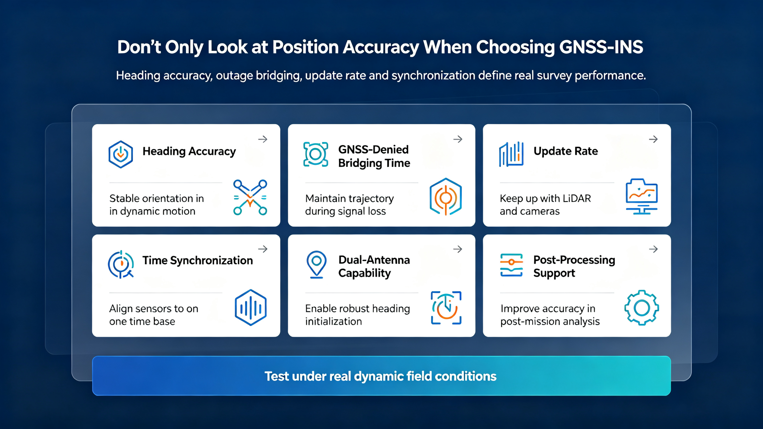
GNSS and INS fail in opposite ways. GNSS is accurate over the long term but intermittent and without attitude. INS is continuous and full-attitude but drifts over time. Put them together and each covers the other's weakness.
The fusion algorithm compares the GNSS position with the INS-predicted position. The difference tells the system how the IMU is drifting, and it continuously corrects that drift. In return, the INS fills in position, velocity, and attitude between GNSS fixes, and carries the system through signal outages. The output is one continuous stream of position, velocity, and attitude at high rate, valid even when GNSS is briefly gone.
Two design details matter in practice.
Dual antenna or not. Heading is the weakest inertial measurement on a moving vehicle. A dual-antenna GNSS setup measures heading directly from the baseline between the two antennas, which stabilizes the solution dramatically. A single-antenna system must derive heading purely from inertial data, which drifts more, especially at low dynamics. For survey work, dual antenna is usually the difference between usable and marginal heading.
Post-processing. Real-time fusion (the loosely and tightly coupled families of algorithms) gives you a live solution in the field. Post-processing, such as PPK and tightly coupled post-processing, uses the recorded raw data, correction data, and forward-backward smoothing to produce a better trajectory after the job. For final survey deliverables, post-processing is routinely the step that turns good data into report-grade data.
The practical message: real-time fusion steers the survey, post-processing closes it.
Why Surveying Specifically Needs It
The fusion is not a nice-to-have. Each survey discipline hits the limits of GNSS alone in its own way.
Mobile mapping. A vehicle with a LiDAR and cameras sweeps the road and its surroundings. The georeferencing quality of the point cloud depends directly on the accuracy of the vehicle's trajectory and attitude. A heading error of 0.1° translates to roughly 17 cm of lateral offset at a range of 100 m, which means every point in the cloud shifts. Mobile mapping is the application that punishes poor attitude accuracy the hardest.
UAV surveying. Drones maneuver fast, vibrate, and fly low, often under tree canopy and close to structures. The INS keeps the trajectory and attitude continuous between GNSS fixes, and it holds through the aggressive banking that makes a loose GNSS solution unreliable. Small, light, tightly coupled systems are the norm here.
Handheld and backpack mapping. Operators walk in and out of buildings, under awnings, and through tree cover, with GNSS dropping constantly. The INS bridges those gaps. These systems live on the low-cost end, where the trade-off between accuracy and price is the most visible.
Marine and bathymetric survey. A vessel pitches and rolls continuously, and the echo sounder needs attitude compensation to correct the depth readings. The INS provides the roll, pitch, and heave the survey software requires.
Rail and road measurement. Long corridors with tunnels, cuttings, and bridges mean long GNSS outages. The INS carries the trajectory through them, and post-processing closes it afterward.
Underground and indoor surveying. In tunnels, mines, and parking structures, GNSS is gone entirely. The INS runs alone, and the survey is planned around the inertial bridge, with GNSS re-acquired at portals and shafts. In these jobs, the bridging spec stops being a nice-to-have and becomes the design constraint of the whole survey.
The Specs That Actually Matter
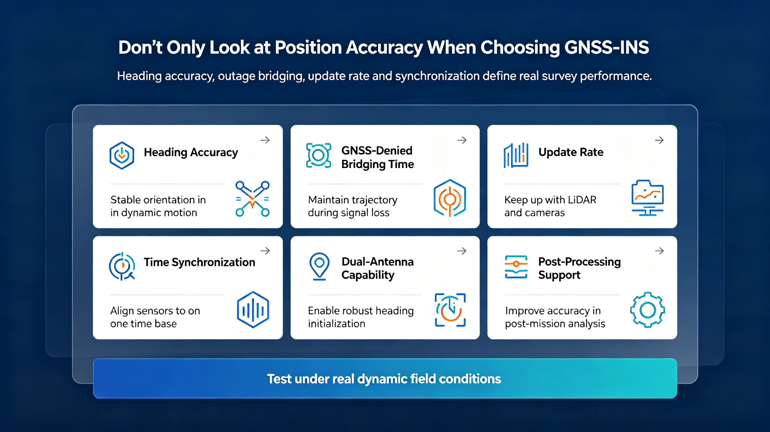
When you compare GNSS/INS systems, most of the marketing sheet does not help you. These six do.
1. Attitude accuracy, heading first. For surveying, heading accuracy is the spec that decides whether the system can do the job. Check it at the dynamics you will actually operate at, not just in a static test. Roll and pitch accuracy matter too, especially for marine work.
2. Position accuracy and the processing mode. Is the system rated for RTK, PPK, or post-processed tightly coupled operation? A system that only promises real-time single-frequency accuracy is not a survey system.
3. GNSS-denied bridging. How long does the system hold usable accuracy after GNSS drops? A bridging spec of tens of seconds at survey-grade accuracy is common for mapping systems. This number tells you how the system behaves in tunnels and under canopy.
4. Update rate. Higher is better for fast-moving sensors and aggressive dynamics. A system that outputs at 100 Hz or more gives the scanner a continuous trajectory to work with.
5. Time sync and event marking. The INS has to be synchronized with the LiDAR, camera, or echo sounder, down to milliseconds, and it has to stamp external events. Without this, the "fusion" never reaches the sensor data. Ask about the sync interface explicitly.
6. Interface and integration fit. Does the system expose the interfaces your software expects, at the power, size, and connector level you can integrate? A great INS that does not fit your platform is a great paperweight.
What GNSS/INS Means for the Survey Workflow
Adding an INS changes the workflow, and it is worth knowing before the first job.
In the field, the system runs in real time. The operator sees a live trajectory and attitude solution, which is enough to check coverage, catch obvious problems, and steer the survey. The raw GNSS and inertial data are recorded continuously during the mission.
After the job, the data goes through post-processing. PPK or tightly coupled post-processing combines the recorded data with correction data and runs the solution forward and backward to smooth it. This is where the trajectory is refined from good to report-grade, and where the final georeferenced point cloud or image is produced.
The workflow consequence is simple: the field crew no longer has to be perfect in real time. A survey that loses GNSS under a bridge or in a tunnel is not wasted, because the INS carried the trajectory and post-processing closed it. That changes how crews plan routes, how many control points they need, and how much rework they schedule. It is one of the quieter reasons the industry moved to integrated systems.
Applications at a Glance
|
Application
|
Key requirement
|
System tier
|
|
Mobile mapping (vehicle LiDAR/camera)
|
High heading and attitude accuracy, dual antenna
|
Ultra-precision
|
|
UAV LiDAR and photogrammetry
|
Tightly coupled, light, high dynamics
|
Cost-effective
|
|
Handheld and backpack mapping
|
Outage tolerance, low cost
|
Cost-efficient
|
|
Marine and bathymetric survey
|
Roll, pitch, heave compensation
|
Mid to high tier
|
|
Rail and road corridor survey
|
Long GNSS outage bridging, post-processing
|
Ultra-precision
|
The table is a starting point, not a rule. A handheld system used for utility mapping can run on the cost-efficient tier, while the same handheld doing as-built documentation of a dense urban corridor may need a higher tier with dual antenna. The environment and the deliverable set the tier, not the platform alone.
Common Mistakes in Choosing a GNSS/INS System
Mistake 1: Buying a receiver when you need a system. A GNSS receiver alone has no attitude. If the deliverable is a georeferenced point cloud or image, the receiver is not the product you need.
Mistake 2: Reading position accuracy and ignoring heading. Marketing sheets lead with position accuracy. For survey work, heading accuracy is usually the limiting spec, and it is the one that gets skipped.
Mistake 3: Single antenna where dynamics are high. If the platform maneuvers, vibrates, or stops and starts, a single-antenna system drifts in heading. Dual antenna is not a luxury in mobile mapping; it is the difference between closing loops and not.
Mistake 4: Ignoring the GNSS-denied bridging spec. In tunnels and under canopy, the system lives on inertial data alone. The bridging number tells you how long the data stays usable. If it is not in the datasheet, ask.
Mistake 5: Skipping time synchronization. The INS and the sensor must share a time base. If the LiDAR frames and the trajectory are not time-synced, the georeferencing is wrong no matter how good the INS is.
Mistake 6: Judging the system on a static demo. Survey-grade INS performance shows in dynamic operation and post-processing. Test it the way you will use it, moving, in the environment, and through the full processing workflow.
FAQ
Q: What is a GNSS-aided INS?
A: A GNSS/INS system fuses satellite position with inertial measurements from gyroscopes and accelerometers. GNSS corrects the inertial drift, and the INS fills in continuous position, velocity, and attitude between GNSS fixes, including through signal outages.
Q: How is it different from an RTK GPS receiver?
A: An RTK receiver gives centimeter-level position but no attitude, and it stops working where the correction link or satellite signal is lost. A GNSS/INS adds continuous full attitude and keeps producing a solution through outages.
Q: Why does heading accuracy matter so much for surveying?
A: Attitude errors rotate the georeferencing of every LiDAR point and image. A heading error of 0.1° shifts points by roughly 17 cm at 100 m range. For mapping accuracy, heading is often the limiting specification.
Q: Do I need dual antenna?
A: For mobile mapping and any high-dynamics platform, dual antenna is strongly recommended because it measures heading directly and stabilizes the solution. Single-antenna systems are lighter and cheaper but derive heading from inertial data alone, which drifts more.
Q: What is PPK post-processing?
A: PPK (post-processed kinematic) combines the recorded raw GNSS data with correction data after the job, using forward and backward smoothing to produce a better trajectory than real-time processing. It is the standard step for final survey-grade deliverables.
Q: Will the system keep working without GNSS?
A: Yes, for a limited time. The INS continues to integrate and hold accuracy through GNSS outages, and the duration of usable accuracy is specified by the bridging performance. In tunnels and under canopy, that bridging is what keeps the survey continuous.
Q: What is the difference between an IMU, an AHRS, and a GNSS/INS?
A: An IMU is the raw sensor core: gyroscopes and accelerometers. An AHRS adds attitude computation and usually a magnetic reference, giving roll, pitch, and heading. A GNSS/INS is the full navigation system, fusing the IMU with GNSS to output position, velocity, and attitude with drift correction and outage bridging. For survey-grade georeferencing, the full GNSS/INS is what you need.
Conclusion
GNSS alone fails in exactly the conditions surveyors work in: no attitude, blocked signals, slow updates, and meter-level raw accuracy. An INS fixes all four but drifts. The GNSS/INS fusion is not a feature; it is the structure of the whole product category, and it is what makes modern mobile mapping, UAV, handheld, and marine survey possible.
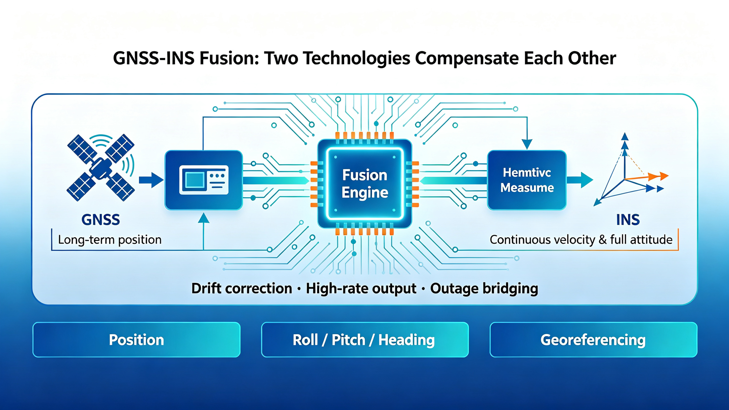
When you pick a system, read the heading accuracy, the GNSS-denied bridging, the update rate, and the time-sync story, not just the position number. And run the test the way you will use it, because a survey system proves itself moving, not sitting on a bench.
If you tell us your platform, the accuracy you need, and the environment you work in, we can match you to the right tier of the GNSS/INS range we build, and tell you when the lower-cost option is the honest recommendation. Send the details through the contact page and we will come back with a specific answer.