

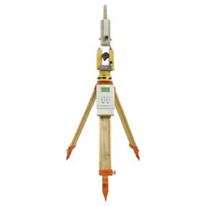
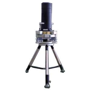
Digital Zenith Photography Position System
Introduction
The Digital Zenith Photography Position System has undergone continuous innovation and improvement, forming a remote automatic monitoring system for vertical deflection, which consists of three parts: Digital Zenith photography, location subsystem, remote control subsystem and alarm warning network subsystem.
Based on the "astronomical geodetic method", we get the geodetic coordinates and astronomical coordinates at the same time, and get the vertical deflection data of the survey stations automatically. Through the network transmission and remote automatic monitoring, we can observe and analyze the plumb line deviation data in real time.
Applications
Geodetic positioning survey, vertical deflection measurement service, precise astronomical survey, earthquake early warning and analysis, crustal tectonic stress field monitoring, regional geoid refinement, military mapping and other fields.
Specifications
| Astronomical latitude measurement error | ≤0.3″ |
| Error in the determination of astronomical longitude | ≤0.02" |
| Mainframe size | ≤Φ430mm×H640 |
| Host quality | ≤54kg |
| Working weather | sunny day and night |
| Ambient temperature | -10℃~+50℃ |
| Relative humidity | 5%~98%(non condensing) |
| Storage temperature | -20℃~+60℃ |
| Operational efficiency | One cycle observation≤30min |
| Average time free time | MTBF≤200h |
| Average repair time | MTTR≤0.5h |
| Electromagnetic compatibility | 10kHz~1GHz、10V/m to 1GHz~18GHz、50V/m |
Application Techniques
2.Do You Know the Application of Gyro Theodolite ?
3.What Instrument Is A Gyro Theodolite?
4.What Is The Principle Of A Gyro Theodolite?
5.What is the Structure of a Gyro Theodolite?
6.How To Orient The Gyro Theodolite?
More Products